The Clark County Office of Emergency Management said in a social media post early Thursday that the primary footprint of maximum snow totals (greater than 6 inches) were shifted northward slightly, and an increase in freezing rain potential was noted across far southern Arkansas. As such, forecast snow totals over southern Arkansas have decreased due to more wintry mix and freezing rain potential.
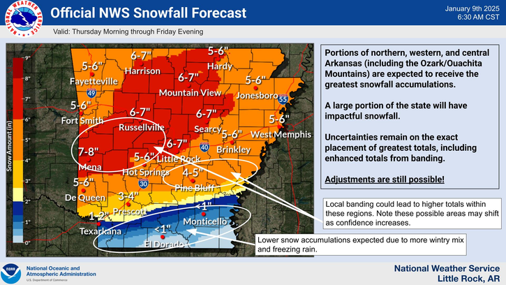
Portions of northern, western, and central Arkansas, including the Ozark/Ouachita Mountains, are expected to receive the greatest snowfall accumulations of 6-8 inches. A large portion of the state will have impactful snowfall. Uncertainties remain on the exact placement of greatest totals, including enhanced totals from banding.

Original post:
Early Tuesday morning, the National Weather Service in Little Rock placed a majority of Arkansas counties under a Winter Storm Watch effective until noon Friday, Jan. 10, 2025. The highest potential for wintry weather will be from Thursday afternoon through Friday morning.
The latest official NWS snowfall forecast, released at 6 a.m. Tuesday, puts the greatest accumulations and associated impacts over western and southwestern Arkansas and the Ouachita Mountains. The official forecast map puts the heaviest snowfall on most of Clark County north of Interstate 30, as well as Pike and Polk counties and portions of Montgomery, Garland and Hot Spring counties.
The NWS warned of major impacts associated with Thursday-Friday’s blizzard, including considerable disruptions to daily life. Dangerous or impossible driving conditions will be possible; avoid travel if possible. Widespread closures and disruptions to infrastructure may also occur.

The Arkadelphia forecast calls for a 90% chance of rain and snow after noon Thursday, with a low around 26. Come Thursday night, expect snow — it could be heavy at times. The snow is forecast to continue through Friday morning, followed by a chance of rain and a high near 33. Nighttime lows will continue to linger in the low 20s to upper teens, with daytime highs just above the freezing mark through Saturday. Daytime temperatures will warm to the 40s by Sunday, but nightly lows will continue to be below freezing.
The weather service remained uncertain on the exact placement of greatest totals and extent of snowfall around the state. Farther south, from Texarkana to Monticello, is an area of greater uncertainty for accumulations and dominant precipitation type (wintry mix versus freezing rain).
Discover more from
Subscribe to get the latest posts sent to your email.