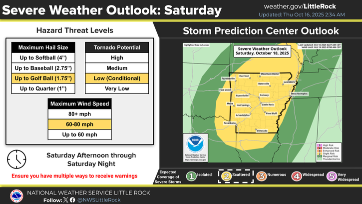
The National Weather Service in Little Rock has placed Arkansas under a Slight Risk for a round of stormy weather predicted Saturday, Oct. 18.
A few storms may remain isolated and will present the greatest risk to produce tornadoes and large hail; however, a complex of thunderstorms are expected to form just ahead of the boundary and track across the state and will create a hazard of damaging wind gusts, the NWS said in an update posted Thursday morning.
Storm development is expected around midday to be crossing into Arkansas and will continue to mature into the afternoon and evening Saturday as the activity pushes from west to east across Arkansas.
As of Thursday morning, Arkadelphia’s Saturday forecast was calling for a slight chance of showers and thunderstorms before 1 p.m., followed by a chance of showers in the afternoon hours and a chance of both showers and thunderstorms after 4 p.m. Chance of precipitation Saturday is 40%.
Saturday night, expect storms through midnight and into early Sunday morning. Chance of precipitation is 70%.
Specific timing remains in question, though the latest trends favor a solution of thunderstorm development along the Arkansas/Oklahoma border by Saturday afternoon. Storms are expected to congeal into a complex as they track eastward, but exactly where this will happen remains uncertain. If storms form into a complex or line earlier in the day, then a tornado an large hail threat will decrease and damaging wind gust potential will increase.
Discover more from
Subscribe to get the latest posts sent to your email.