This post was updated 3/28/25 at 10 a.m.
National Weather Service in Little Rock
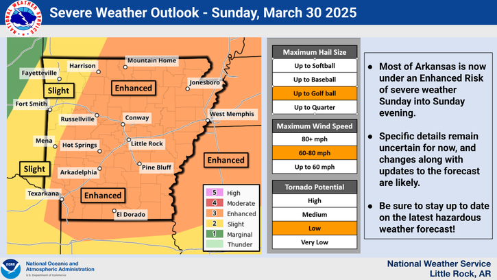
Severe weather will be possible Sunday into Sunday evening, March 30, 2025, over a large part of Arkansas where an enhanced risk of severe weather exists pretty much statewide. Strong to severe thunderstorms will be possible with all modes of severe weather including tornadoes not out of the question.
While all of Arkansas has the potential to see some strong or severe storms, the greatest confidence where the activity could be focused appears to be over portions of central and eastern Arkansas.
The severe weather threat increases Sunday with a cold front pushing through from the west. Large hail (2 inches or greater) and damaging winds will be the main threat along the I-30 corridor and east. Southeastern Arkansas will have the greatest threat for severe weather in the late evening before the line of storms moves east.
There will likely be adjustments to the forecast over the next few days. Eastern and southern sections of the state should remain weather aware: know your safe places, make sure you have emergency supplies on hand, and have a family communication plan.
A majority of the state may see strong to severe thunderstorms on Sunday; however, with the event still six days in advance this forecast is likely to change. Additionally, in the next few days details regarding timing, severe weather hazard types, and general location will become clearer.
With showers likely developing Friday afternoon, Arkadelphia’s weekend forecast calls for a 90% chance of showers Friday night, with thunderstorms developing after 10 p.m. and an increased chance of precipitation, 70%. Between one-quarter and one-half inch of new rainfall is possible.
Showers and thunderstorms are likely to continue into Saturday. Chance of precipitation is 60%. New rainfall amounts could total between one-tenth and one-quarter inch, with higher amounts during thunderstorms.
Sunday’s local forecast calls for a 60% chance of showers and thunderstorms after 1 p.m. with mostly cloudy skies, a high near 80, and a south wind of 5-10 mph with gusts as high as 20 mph. Sunday night will have a low around 49.
Sunny skies will return Monday, followed by more chances of precipitation Tuesday night into Wednesday.
Discover more from
Subscribe to get the latest posts sent to your email.