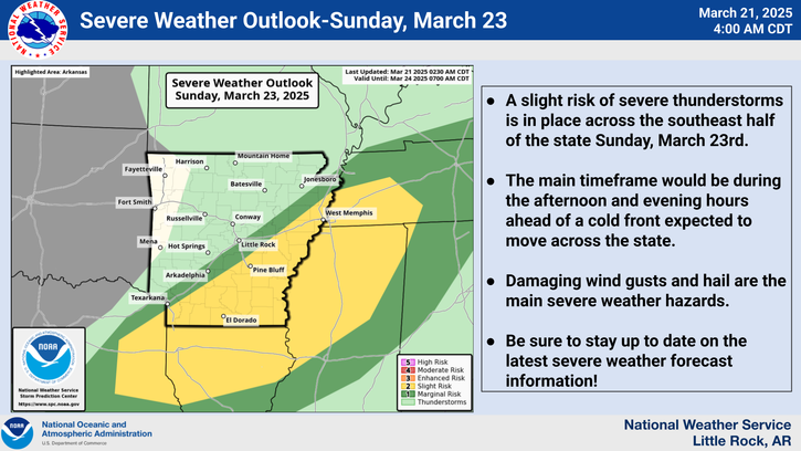
Strong to severe thunderstorms are possible across the southeast half of Arkansas on Sunday afternoon and evening, March 23, 2025, the National Weather Service in Little Rock said.
Damaging wind gusts and hail are the main severe weather hazards. The main timeframe would be during the afternoon and evening hours ahead of a cold front expected to move across the state.
The weekend forecast for the Arkadelphia area calls for a mostly clear Saturday, with a high near 74 and calm winds. Temperatures will fall to the mid 50s Saturday night as winds pick up, with gusts as high as 20 mph.
There is a local chance of showers Sunday between 1-4 p.m., with a chance of thunderstorms after 4 p.m. Expect mostly cloudy skies with slight winds of 10 mph and a high near 75. Sunday’s precipitation chances are 40%, with slighter chances that night and a low in the mid 40s.
Clouds should part by Monday, with clear skies through Wednesday; highs will be in the mid to upper 70s and lows will be in the mid 40s.
Fire danger still high for Arkansas
Gusty south and southwest winds returned Friday to much of Arkansas, adding to the already-dangerous wildfire conditions. A majority of counties are now under burn bans.
Clark County and its neighboring counties (with the exception of Nevada County) remained under a burn ban on Friday.
The fire danger remains high across the state with Red Flag Warnings.
Discover more from
Subscribe to get the latest posts sent to your email.