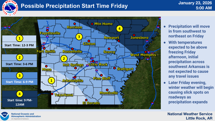
MAP: With a significant winter storm on our doorstep, you may be wondering what is a reasonable start time for precipitation to begin at your particular location today. This map tries to best convey those questions. In general, precipitation should begin over southwest Arkansas early in the afternoon, then spread northeastward through the afternoon into the late evening hours tonight. | National Weather Service in Little Rock graphic
A complex winter storm will move across Arkansas beginning this afternoon and lasting through Sunday. The National Weather Service in Little Rock says that all precipitation types are expected across the state, with mostly snow for the northern portions, sleet with periods of freezing rain and snow across the central portions, and freezing rain with periods of sleet across the southern portions of the state being the latest update to the forecast. Expect Moderate to Major impacts across Arkansas through Sunday, with impacts felt going into early next week as any frozen precipitation will be slow to melt due to the very cold temperatures to follow.
Snow
The latest official snow forecast suggests the greatest snow totals are expected over north Arkansas, with lesser totals over central to south Arkansas due to greater sleet potential. The chance for high-end snow totals in excess of 12 inches is currently favored across northwest to north central Arkansas. It is important to note, this official snowfall accumulation forecast includes both potential snowfall and potential sleet accumulations.

Sleet
Significant amounts of sleet ranging from 2 to 4 inches will be possible across west central, central, east, and southwest Arkansas. Important note, do not add this sleet accumulation forecast to the snowfall accumulation forecast. The sleet accumulation amounts in this graphic makeup some or all of the expected snowfall amounts (reference the Snow Forecast tab). These amounts should not be considered “additional” accumulation, but rather some or all of the expected snowfall for the storm total.

Freezing rain
The latest official ice accumulation forecast shows much of south Arkansas will see the greatest ice accumulations, but the potential for a glaze to one tenth of an inch is creeping further north for this event.

Arkadelphia: Sleet, then snow, then freezing rain Friday, followed by more freezing rain, heavy sleet and mix Saturday
The winter storm expected this weekend will bring a mix of ice and snow to the Arkadelphia area, according to the latest forecast from the National Weather Service in Little Rock.
On Thursday, the NWS issued a statewide Winter Storm Warning effective midday Friday through Sunday night. Additionally, an Extreme Cold Watch will be effective Friday night through Monday, Jan. 26.
Starting around mid-afternoon Friday, there will be a slight chance of sleet, followed by snow showers before dusk. Expect wind gusts as high as 25 mph. Friday night into Saturday morning, expect freezing rain and sleet with a low around 14 and wind chill values as low as 2. Winds will gust as high as 20 mph.
Saturday, more freezing rain and sleet, which could be heavy at times. Chance of precipitation is 100% Windy conditions will persist Saturday with gusts as high as 20 mph. Saturday’s high of 20 will plummet to 13 Saturday night.
Sunday brings a 50% chance of snow, freezing rain and sleet before noon, followed by more snow. Mostly cloudy skies with a high near 22 and a 5 mph breeze. Sunday’s high temperature of 22 will plunge to a low around 1 that night.
Sleet and snow accumulations of 1-4 inches are expected over central sections of the state, with sleet and ice accumulations up to 1 inch possible across the southern and southeast sections.
Roads, and especially bridges and overpasses, will likely become slick and hazardous. Expect power outages and tree damage due to the ice.
Travel could be impossible. The hazardous conditions could impact the Friday evening commute. Those who must travel should keep an extra flashlight, food and water in their vehicle in case of an emergency. Check the latest road conditions at http://www.idrivearkansas.com.
Storm impacts
Expect Moderate to Major impacts across Arkansas through Sunday, with impacts felt going into early next week as any frozen precipitation will be slow to melt due to the very cold temperatures to follow.

Extreme cold
In addition to the high impact winter storm, very cold temperatures and wind chills will filter into the region this weekend and extend into early next week. Expect overnight lows to dip into the single digits below for northern Arkansas, near zero for central Arkansas, and single digits above for southern Arkansas starting Sunday night.
Dress in layers including a hat, face mask and gloves if you must go outdoors. Wrap or drain water pipes, or allow them to drip slowly to prevent freezing.
Make sure outdoor animals have a warm, dry s heater, food and unfrozen water.
Make frequent checks on older family, friends and neighbors.
Ensure that portable heaters are used correctly, and do not use generators or grills indoors.
Gradual warming is anticipated early next week, but Monday night lows into Tuesday morning area currently forecasted to generally be in the single digits above across the state.
Discover more from
Subscribe to get the latest posts sent to your email.