National Weather Service image
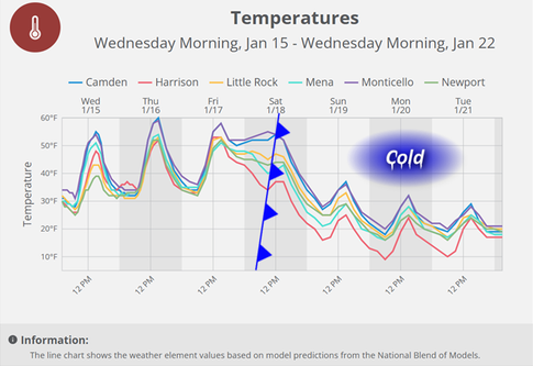
Expect a “roller coaster of temperatures” over the next several days as a warming trend exits this weekend to make way for a blast of Arctic air, the National Weather Service in Little Rock warned.
Daily highs will linger in the mid-50s until a cold front sweeps through the region by Saturday afternoon, plunging temperatures to below freezing through the middle of next week.
While showers are expected Friday, chances for wintry precipitation during the cold snap appeared “minimal”, the NWS website said Wednesday. A southern track storm system is brewing early next week for the states north of the Gulf of Mexico, but any impacts to portions of Arkansas were not yet known.
The coldest conditions should settle into Arkansas on Monday, Tuesday and possibly beyond. Temperatures are expected to be 10-20 degrees below climatological averages.
The seven-day forecast for the Arkadelphia area calls for a breezy and potentially wet Friday, followed by a Saturday high of 52 under partly sunny skies as the cold air moves in. Nighttime lows from Saturday through Tuesday (the latest day included in the forecast) will sink to the 20s, with daytime highs below the freezing mark.
Discover more from
Subscribe to get the latest posts sent to your email.